UPPER/LOWER RED LAKE WATERSHED IMPAIRED WATERS
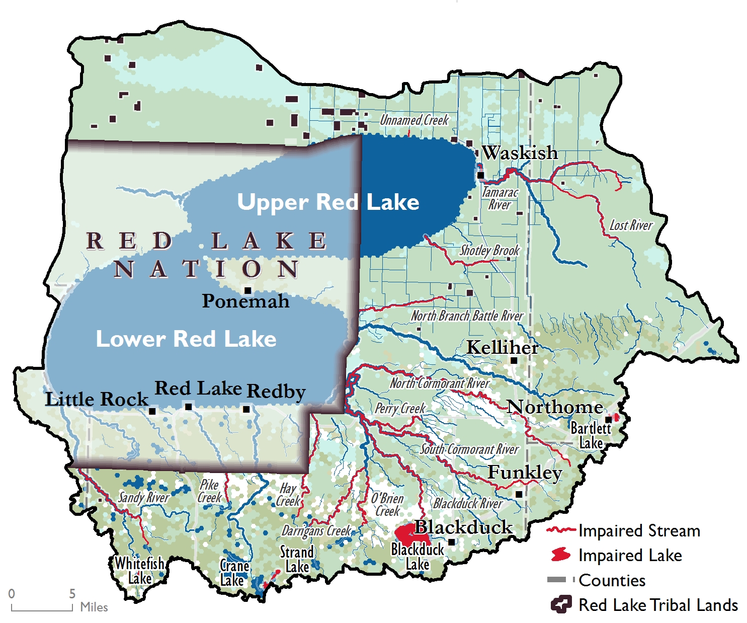
The map below shows the impaired waters in the watershed. More detailed information can be found in the Monitoring and Assessment Report. Next steps will include suggestions for strategies, or projects, that can be implemented to help fix these issues and improve water quality as well as protect areas that have been identified as high quality waters. A Watershed Restoration and Protection Strategy (WRAPS) Report and Total Maximum Daily Load (TMDL) Report will include this information. Please continue to watch this web page for when those documents are available.

PUBLIC MEETING SCHEDULED FOR DECEMBER 2019
A public meeting for the Upper/Lower Red Lake WRAPS has been scheduled for local citizens to become involved with projects and implementation strategies for restoration and protection of the watershed.
Please join us for an open house with opportunities to meet with staff from your local Soil and Water Conservation District (SWCD), Natural Resources Conservation Service (NRCS), Board of Water and Soil Resources (BWSR), the Red Lake Watershed District, as well as representatives from the Minnesota Pollution Control Agency, Minnesota Department of Natural Resources, and Red Lake Department of Natural Resources. Snacks and refreshments will be served.
North Beltrami Community Center
220 Main St. E, Kelliher, MN
Thursday, December 12th from 4:00-6:00 pm
Input from the meeting will be incorporated into the final WRAPS report that will be submitted to MPCA in early 2020.
For additional information or questions about this meeting, please contact Kayla Bowe at the Red Lake DNR: 218-679-1607 or kayla.bowe@redlakenation.org.
LINKS TO WRAPS DOCUMENTS
Thank you to all who were able to attend the public meeting in Kelliher on April 24th. Please use the links below to access reports that have been produced for the WRAPS:
Monitoring and Assessment Report
Stressor Identification Report
You can also visit the Minnesota Pollution Control Agency's website for more information regarding the Upper/Lower Red Lake Watershed WRAPS project here: Upper/Lower Red Lake Watershed.
PUBLIC MEETING SCHEDULED FOR SPRING 2018
A public meeting for the Upper/Lower Red Lake WRAPS has been scheduled. The purpose of this meeting is to show which lakes and streams are in good condition and which are not within the watershed. A few brief presentations will be provided regarding the biological work, stressor identification process, and an overview of the WRAPS process. Cookies and refreshments will be served.
In addition to the presentations, representatives from various agencies will be in attendance to have one-on-one conversations to provide you with more information on the status of the biological community data, water chemistry, stream channel stability, geomorphology, stressor identification, and modeling from the watershed.
North Beltrami Community Center
220 Main St. E, Kelliher, MN
Tuesday, April 24th from 4:00-6:30 pm
For additional information or questions about this meeting, please contact Kayla Bowe at the Red Lake DNR: 218-679-1607 or kayla.bowe@redlakenation.org.

BIBLIOGRAPHY FOR THE UPPER/LOWER RED LAKE WRAPS
A bibliography has been compiled of studies and reports relating to water quality in the Upper/Lower Red Lake Watershed. Please click on the link below to see the bibliography. Direct hyperlinks to PDFs of the studies are referenced within the bibliography.
PUBLIC MEETINGS SCHEDULED FOR FALL 2016
The public meetings for the Upper/Lower Red Lake WRAPS have been scheduled. These will be an open house format; there is no need to attend the entire two-hour session. Please come when it works best for you. Cookies and refreshments will be served.
Open house format means representatives from various agencies will be in attendance at the Kelliher meeting to have one-on-one conversations to provide you with more information on the status of the biological community data, water chemistry, stream channel stability, geomorphology, and modeling status and general modeling information from the watershed.
Red Lake DNR Water Resources staff will provide this information and opportunities for one-on-one conversation at the Ponemah and Red Lake meetings.
North Beltrami Community Center
220 Main St. E, Kelliher, MN
Tuesday, October 11th from 5-7 pm
Ponemah Boys & Girls Club/Community Center
Wednesday, October 12th from 5-7 pm
Red Lake DNR
Thursday, October 13th from 5-7 pm
For additional information or questions about these meetings, please contact Kayla Bowe at the Red Lake DNR: 218-679-1607 or kayla.bowe@redlakenation.org.

UPPER/LOWER RED LAKE WATERSHED RESTORATION AND PROTECTION STRATEGY
The Upper/Lower Red Lake Watershed covers 1,263,678 acres and contains the largest waterbody within the state (Red Lake). The watershed extends from as far east as Northome to the western shores of Lower Red Lake, south as far as Puposky and Blackduck Lakes, and just north of Upper Red Lake.
The Red Lake DNR Water Resources Program is leading a watershed-wide study to identify and address threats to water quality not only on the Red Lake Reservation but throughout the Upper/Lower Red Lake Watershed. This study is funded by the Minnesota Pollution Control Agency (MPCA) but will include many partners throughout the watershed such as Beltrami SWCD, Red Lake Watershed District, and local governments.
Through this process, the program has begun more intensive water quality sampling of some of the Reservation’s streams and those feeding into Red Lake from off the Reservation. Some of the Reservation streams include the Red Lake River, Sandy River, Pike Creek, Big Rock Creek, Mud River, Hay Creek, Blackduck River, and Manomin Creek. Over the next two years, physical parameters (temperature, dissolved oxygen, pH, and conductivity) will be recorded more frequently along with nutrient sampling and flow monitoring on these streams.
This project also assesses the biotic integrity (health of fish, plants, and aquatic macroinvertebrates) of the waters and physical characteristics including land use, topography, soils, and pollution sources. From the data gathered, we will determine which waterbodies are meeting water quality standards. Waterbodies that are not meeting standards are identified as impaired and studies are completed to identify what needs to be done to clean up that water body. Additionally, waterbodies that are at risk of being impaired have protection strategies developed. The final phase of a WRAPS is to conduct restoration and protection projects throughout the watershed.
The Water Resources Program will be hosting a public meeting sometime in the next year to provide more information regarding the WRAPS process and to seek input or concerns from Tribal members on water quality of Reservation waters.


